
Now Showing: Rare Maps and Atlases
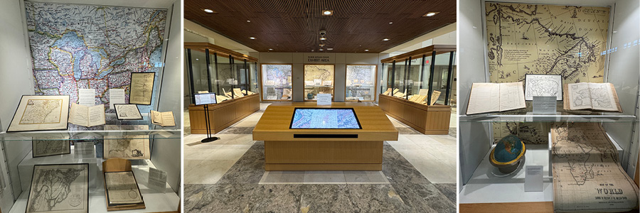
Rare book and map collections from UT Libraries’ special collections and archives are now on display on the first floor of Hodges Library.
The exhibit features maps, atlases, and geographical texts that range from global perspectives to localized charts of Tennessee and the American South. Spanning the 16th through the 19th centuries, the materials demonstrate how explorers, governments, militaries, and travelers used cartography as a distinct language.
A few examples of particular local interest:
- A New and Accurate Map of the Provinces of North and South Carolina, Georgia &c. Drawn from Late Surveys and Regulated by Astronomical Observations, 1752. A map depicting Native American towns and English forts in the Tennessee country prior to the French and Indian War.
- Carte de la Caroline et Georgie. Pour servir à l'histoire générale des voyages, 1757. This multi-volume encyclopedia by the French Navy's first official hydrographer advanced European cartography by applying strict mathematical rigor to maritime coastlines, prioritizing navigation over artistic embellishment. The map on display illustrates the coastlines, early settlements, and frontier outposts of North and South Carolina and Georgia and is highly valued for its detailed depiction of the backcountry, including the territories, trade paths, and villages of the Cherokee and Creek nations.
- A map created by British army officer Henry Timberlake who served in several campaigns during the French and Indian War and in 1761 volunteered to visit the Cherokee villages on the Little Tennessee River to explain the provisions of the peace treaty. His remarkably accurate map located all the Cherokee villages on the lower Little Tennessee River and provided important demographic information about village sizes, populations, and leaders. In the 1970s, archaeologists working on the Tellico Archaeological Project relied directly on the incredible accuracy of this map to locate and excavate the physical sites of these historic Cherokee towns before they were submerged by Tellico Lake.
- An 1842 map of East Tennessee from J. Gray Smith’s pamphlet, A Brief Historical, Statistical, and Descriptive Review of East Tennessee in the United States of America. Designed to lure English immigrants to East Tennessee, the map highlights vast farmlands, rich mineral deposits (including a "gold mine district"), established roads, and a planned railroad to Knoxville. Ultimately, the map served as a marketing tool for the East Tennessee Land Company to sell local farms.
- Topographical Map of the approaches and defenses of Knoxville, E. Tennessee, showing the positions occupied by the United States and Confederate forces during the siege, 1863. Focusing on the November–December 1863 Siege of Knoxville, this map documents Union General Ambrose Burnside’s defensive fortifications — including Fort Sanders — and Confederate General James Longstreet’s failed attempts to recapture the city, emphasizing the role of terrain and man-made structures in the conflict.
The exhibit — as well as being a veritable treasure trove of beautiful historical texts — is a lesson in the progression of the science and practice of drawing maps.
The exhibit outside the Betsey B. Creekmore Special Collections and University Archives, 121 Hodges Library, will be on display throughout the 2026 Fall Semester.